
The best cameras with GPS aren’t as common as they once were. But if you want to record the exact location of where your photos and videos were taken, there are still cameras with built-in GPS modules that will record location information (and sometimes more) into the EXIF data.
As the function has become less common, the best cameras with GPS are now either top-end professional bodies or outdoor-focused action and waterproof cameras.
The reason that integrated GPS modules are rarer is that cameras now rely on smartphone connectivity. However, as anyone who's used a phone app for their camera can attest, they are at best fiddly and at worst completely unreliable!
This list only features the best cameras with GPS built-in, so you don't have to rely on apps or phones – and only includes cameras currently on the market (even though, ironically, older cameras are more likely to have it!).

James has 26 years experience as a journalist and started working in the photographic industry in 2014. As one of DCW's principal testers, he has a tested all the cameras in this guide – and actually owns a few of them personally!
The best cameras with GPS in 2026
Why you can trust Digital Camera World Our expert reviewers spend hours testing and comparing products and services so you can choose the best for you. Find out how we test.
Best compact camera with GPS

The OM System Tough TG-7 is, in terms of pure functionality, the best camera with GPS period. Which is amazing, when you consider how small this camera is!
Its GPS capabilities are part of a full Field Sensor System. So it not only logs latitude and longitude coordinates for location geotagging, it also has a compass to track directional data, a manometer to track altitude or depth (when above or below sea level) and a thermometer for logging air and water temp.
So whether you want to record the conditions when you climbed Everest, how high you skydived from, how deep you scuba dived, or you just want to prove that it really was the hottest day of the year when you took a particular photo, the TG-7 is the only camera here that can do it.
On top of that, it's also the most rugged consumer camera you can buy. It's waterproof, shockproof, freezeproof and crushproof, so it can take a pounding and keep on shooting.
As a camera, it punches well above its (249g) weight. The 1/2.33in might be small, with a relatively conservative 12MP resolution, but its backlit construction and larger photosites boost its low light shooting power – which is very useful when shooting underwater.
Its 25-100mm (full frame equivalent) f/2.0-4/9 lens is versatile for everyday shooting, and boasts a fantastic macro mode for superb close-up shooting. And among the many OM System Tough TG-7 accessories are some lens adapters if you want to experiment.
It has some serious photographic firepower for a compact camera, with RAW shooting and up to 20fps burst shooting – along with Pro Capture (10fps) for pre-release shooting before you even press the shutter.
While it shoots 4K 30p / FullHD 120p, its video features aren't a match for current smartphones or action cameras, but they still do the job when you're in the field.
Read my full OM System Tough TG-7 review
Best Canon camera with GPS
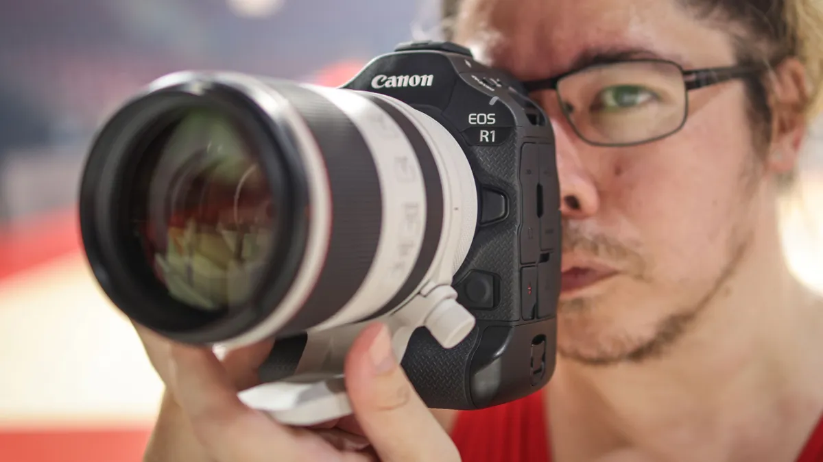
Canon has mostly stripped GPS out of its mirrorless range, with the Canon EOS R3 the only other R System body to feature it. Which does mean that only the company's top-tier professional cameras can log GPS data natively.
That does make some sense, though, as it enables reporters, journalists and newsgatherers to verify and log where images were captured.
And this is just the tip of what the R1, the company's flagship camera, can do. On paper it has a 24MP sensor, but it also boasts Neural network Image Processing features including in-camera upscaling – which enables you to turn your 24MP stills into 96MP files. There's also in-camera denoising, which cleans up ISO performance by two stops.
The Dual Pixel Intelligent AF system uses algorithmic and computational cleverness for the most robust autofocus system on the market, features like Action Priority mode that can intelligently recognize, track and prioritize the movements of sports players when a ball is in the frame.
Sports and action shooters will love the 40fps burst shooting as well as Pre-Continuous Shooting to record the frames before you fully depress the shutter. It's also a capable video machine, with up to 6K 60p capture in Canon Log2.
And of course, it also boasts a "pro" body with integrated vertical grip and a larger battery – something that isn't just useful for pros, but for anyone who spends long days shooting in the field (especially with longer lenses!). But if you want a casual carry-around camera, that extra bulk might not be what you're after!
Read my full Canon EOS R1 review
Best action camera with GPS

With GoPro on life support (and the Mission 1 Pro being premium priced), this category is down to DJI and Insta360. And while the Osmo Action 5 Pro is a great camera (the 6 Pro doesn't have GPS), for me the Ace Pro 2 is the best all-purpose action cam for its sheer adaptability.
Out of the box it's super versatile thanks to its 180° flip-up screen, which is perfect for vlogging as well as mounting situations (such as the handlbars on your bike) where a fixed rear screen is hard to see.
Its video is incredibly capable, with a maximum resolution of 8K 30p as well as slow-motion-friendly framerates of 4K 120p and FullHD 240p. And being an action camera, it's waterproof down to 39ft / 12m.
However, unlike most action cams, the Ace Pro 2 is also a great photographic device. That's not just thanks to its 50MP stills and Leica Summarit lens, but also to its modularity.
With the Xplorer Grip it becomes a great tool for street photography, and by adding the Pocket Printer it becomes an instant camera that spits out photos as you go!
Read our full Insta360 Ace Pro 2 review
Best DSLR with GPS

Old but still gold! The only other DSLRs with a built-in GPS still on the market are the Canon EOS-1D X Mark III (the former flagship body), the Nikon D6 (a premium-priced professional camera) and the Pentax K-1 Mark II (an old DSLR with limited support), making the trusty 5D Mark IV my top pick.
It's been trusted by enthusiasts and pros for years, and is still one of the most ubiquitous cameras on the market. Its 30.4MP sensor delivers crisp image quality with good noise control and dynamic range performance, with brilliant build quality, ergonomics and weather sealing.
The 4K video is subject to a 1.64x crop, however, which can make it tough to get suitably wide-angle shots. It's also worth noting that the rear screen is fixed – not fully articulating nor even tilting, which can be annoying for those who prefer shooting in live view.
Essentially the 5D Mark IV is about equivalent to the original Canon EOS R, but with the benefit of dual memory card slots (and, of course, built-in GPS). It remains an absolute workhorse – and the fact that it's still in Canon's active lineup after ten years and the R-system revolution speaks for itself.
Read our full Canon EOS 5D IV review
Best Nikon camera with GPS
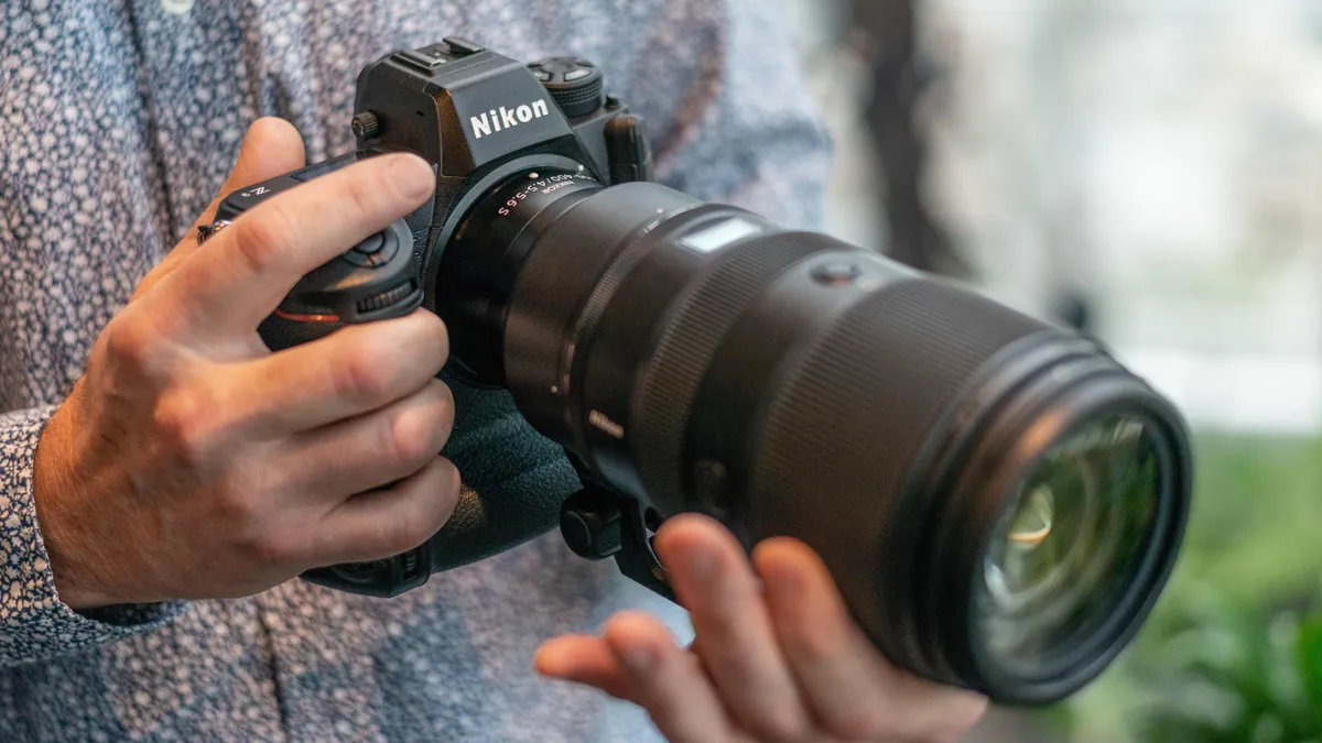
Like Canon, Nikon has stripped GPS functionality from all its non-pro mirrorless models – which means that the only other Nikon camera with GPS still on the market is the D6 DSLR. And the Z9 outclasses it in every way.
This pro-spec mirrorless camera is designed to do just about everything. Its meaty 45.7MP full-frame sensor gives you all the image quality you could ask for, whatever you're shooting. And it's backed by Nikon's most robust autofocus system ever, with fantastic tracking and algorithmic subject recognition.
It's a machine-gun shooter, too, with a maximum burst rate of an incredible 120fps – albeit at a dropped resolution of 11MP (for full-resolution 45.7MP RAW shooting, you're limited to 20fps) – making this a beast for wildlife and sports. And it's also a killer video device, with up to 8K 60p recording giving you ultra-crisp capture.
Like the Canon EOS R1 on this list, this is a flagship professional camera – which means you get a "pro DSLR" body with integrated vertical grip and bigger battery capacity. That can be a blessing or a curse, depending on what you want from this camera.
Still, whatever it is that you want, the Z9 can do it. It might be the best bang-for-buck do-it-all camera on the market.
Read my full Nikon Z9 review
How to choose the best cameras with GPS
GPS, when you get down to it, is a fairly simple feature – generally, cameras either have it or they don't. That means, rather than thinking about the specifics of the GPS itself, the best thing to do is to think about what type of camera it is you want. Do you want to be able to change lenses, or will a fixed prime or zoom lens suffice? Think about whether you need waterproofing – this is a common requirement for those looking for GPS-enabled cameras, as they tend to be looking to log their holidays or other travels. If that's you, a tough compact or an action camera will fit the bill.
However, if you're looking for GPS from more of a professional perspective – perhaps you're a journalist or documentarian who needs a precise log of where each image was taken – then you're best off with one of the more sophisticated interchangeable-lens cameras on this list.
How we test cameras with GPS
At DCW, we put every camera that comes through our doors through the same battery of testing and analysis. Our team of expert photographers, videographers and writers use a series of scientific lab tests to measure how a camera performs. For mirrorless and DSLR cameras, we focus on resolution, dynamic range and noise performance. For things like action cameras, such as the GoPro Hero11 featured in this guide, it's more practical (and more relevant to the userbase) to focus more heavily on real-world performance.
This means doing something all our reviewers love getting to do – taking a camera out into the world and testing how it feels to use. This includes looking at features like GPS – if a camera advertises itself as having GPS, how well does it work? Is the signal consistently reliable? Is the option easy to find, and does the data embed itself reliably in images/videos?
If you're interested, you can learn more about how we test at Digital Camera World.
FAQs
What is GPS?
GPS, which stands for Global Positioning System, is a means of determining the location of a specific point on Earth, within a reasonable degree of accuracy. It works via a system of more than 30 satellites owned and operated by the United States government – though you don't need to be affiliated with said government in order to use it. You just need a GPS receiver.
If a GPS receiver is within line of sight of at least four of those satellites, the system is able to accurately determine its geolocation. Some receivers are more accurate than others – the ones in commercially available smartphones are quite a bit less sophisticated than those used by the US military.
Which cameras have built-in GPS?
Historically, a lot more cameras had integrated GPS modules. However, with smartphones now being in everyone's pockets, most manufacturers eschew a built-in GPS in favor of tethering to phones to gather location data. (Again, the cameras on this list have their own dedicated modules.)
As such, most models have now been discontinued. But recent cameras with built-in GPS include the following:
- Canon EOS-1D X Mark III
- Canon EOS 5D Mark IV
- Canon EOS 6D Mark II
- Canon EOS R1
- Canon EOS R3
- DJI Osmo Action 5 Pro
- GoPro Hero13 Black
- GoPro Mission 1 Pro
- Hasselblad X1D II 50C
- Insta360 Ace Pro 2
- Nikon Z9
- Nikon D6
- Nikon Coolpix P900
- Pentax K-1 Mark II
- OM System Tough TG-7
Do you need the internet for GPS to work?
No. GPS works completely independently of WiFi or cellular data and does not require an internet connection in order to function.
What is the best GPS camera?
The best GPS camera really depends on what it is you're shooting. In my opinion, the OM System Tough TG-7 is the best compact camera with GPS (along with a full Field Sensor System), the Canon EOS R1 is the best Canon camera with GPS, and the Insta360 Ace Pro 2 is the best action camera with GPS.

