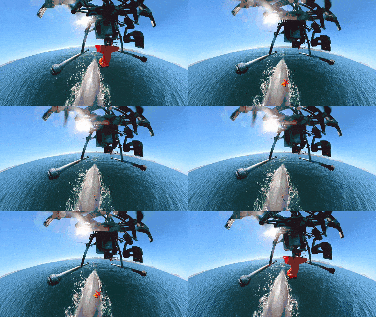
Watch this camera drone tag a whale from above!
Discover how DJI camera drones are tagging whales from above and transforming marine research, again

Picture a scene that’s synonymous with the climate crisis. Maybe your mind jumped to the Amazon rainforest or the polar ice caps, where deforestation and rapid melting have long been rallying points for conservation efforts. But the latest research suggests it’s oceans that are key to tempering climate change.
In fact, a microorganism you’ve probably never heard of captures 40% of Earth’s carbon emissions and produces oxygen for two out of every three breaths you take. These microscopic algae are called phytoplankton. It’s both the cornerstone of the marine ecosystem and a highly effective carbon capture system.
• Looking for the best DJI drones?
Phytoplankton depends on a steady supply of nutrients, including phosphorus, iron, and nitrogen. Fortunately, right at the top of the ocean food chain lives an incredibly efficient fertilizing machine: the whale.
Drones have given scientists and research teams around the world an affordable but game-changing way to gather data. Nowhere is that clearer than the field of marine conservation, where research missions have traditionally been limited to well-funded projects and a privileged few.
For Dr Iain Kerr and the team at Ocean Alliance, camera drones have democratized access to ocean research and revolutionized the way whale data is gathered. The SnotBot concept turns DJI drones into flying Petri dishes – it’s crude, inspiring, and utterly brilliant. As a result, Kerr’s team has captured the imaginations of countless conservationists.
Sea Shepherd used DJI drones to track and log illegal fishing activity in the South Indian Ocean. With an eye in the sky, the team captured evidence of illegal drift nets and documented the crew attempting to hide evidence of their activities.
The best camera deals, reviews, product advice, and unmissable photography news, direct to your inbox!
On dry land, drones are supporting conservation efforts from Antarctica to Borneo. Often researchers simply need to count animal populations to understand the challenges they face over time. However, nature rarely forms an orderly queue. Combined with image recognition software, drones offer a quick and cost-effective way to scan large areas, operating high above terrain that would otherwise be difficult for teams on the ground to access.
Whether it’s mapping the location of 300,000 nesting pairs of Adélie penguins or using thermal imaging to detect the heat signatures of polar bear dens, drones are empowering environmental projects.
Read more:
Best camera drone
Best underwater drone
Best drone for kids

For nearly two decades Sebastian's work has been published internationally. Originally specializing in Equestrianism, his visuals have been used by the leading names in the equestrian industry such as The Fédération Equestre Internationale (FEI), The Jockey Club, Horse & Hound, and many more for various advertising campaigns, books, and pre/post-event highlights.
He is a Fellow of the Royal Society of Arts, holds a Foundation Degree in Equitation Science, and holds a Master of Arts in Publishing. He is a member of Nikon NPS and has been a Nikon user since his film days using a Nikon F5. He saw the digital transition with Nikon's D series cameras and is still, to this day, the youngest member to be elected into BEWA, the British Equestrian Writers' Association.
He is familiar with and shows great interest in 35mm, medium, and large-format photography, using products by Leica, Phase One, Hasselblad, Alpa, and Sinar. Sebastian has also used many cinema cameras from Sony, RED, ARRI, and everything in between. He now spends his spare time using his trusted Leica M-E or Leica M2, shooting Street/Documentary photography as he sees it, usually in Black and White.
